Sun and shade areas create microclimates in the landscape that may or may not be desirable. Identify existing sun and shade areas on the property map when conducting the landscape inventory. Once these areas are identified, use the landscape analysis to plan locations for new sun or shade areas. In some cases, sun areas will need to be created by removing plants. In other cases areas more shade will be needed.
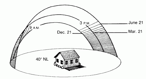
Path and angle of the sun in March, June, and December in the northern hemisphere
Image source: Knowledge Publications
Identify:
1. Daily sun and shade patterns from existing vegetation and structures
2. Seasonal sun and shade patterns from existing vegetation and structures
3. Sun and shade areas affecting heat, cooling, and light into buildings
4. Sun and shade areas affecting plant choice decisions and locations
5. Mature size when planning for tree placement